Spy Satellite Expert Explains How to Analyze Satellite Imagery
Released on 07/13/2021
If we look back through time,
[tape rewinding]
there's always been this desire to get a higher picture.
[calm music]
We continued to go higher and higher
to get a better and better picture
to understand what's going on.
I'm Keith Masback.
I've been working in the remote sensing field
for over 30 years.
[typewriter clacking]
Today I'm going to share with you just a few tips and tricks
on how to look at satellite imagery.
The coordinates are in the description
if you want to follow along.
[calm music]
[typewriter clacking]
So the first thing I'd say
is that you never want to look at just one image.
You want to understand context,
and you want to understand a place over time
because that's really where you're going to start
to be able to pull some real observations.
The benefit of looking at someplace over time
is you're being able to see patterns.
You're being able to see progression.
Why don't we look at some examples in nature.
One rule of thumb in the imagery analysis business
is mother nature doesn't make a lot of straight lines.
So your eyes, an imagery analyst
immediately goes to anything that looks perfectly straight.
Another example is deforestation.
Again, that's man-made activity
that comes really, really clear on remote sensing,
especially from space.
Men tends to cut things in very clear patterns.
So you see sort of football field size pieces
disappear at a time.
It's very easy to see despite whatever a country
or a region or a company might be saying they're doing,
it's pretty easy to call them out.
So one case I might point to is what's going on
in the Arctic and the retreat of glaciers.
You can start to see how they're depositing sediment
and how the sediment is being increasingly exposed
to the sun instead of the very white ice
reflecting the sun's rays,
that sediment is actually collecting heat
and contributing in turn
to a faster retreat of those glaciers.
Next let's turn to man-made structures,
man-made activity that certainly important
in my background is looking at military activity.
Military people tend to like order.
They like to do things repeatedly.
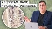
During the cold war,
we would watch the Soviet rigidly adhere to doctrine.
They would always assemble their forces in the same way.
And in fact, today, even the Russians still tend to do that.
We're seeing very similar patterns
to what we saw when they invaded Crimea several years ago,
their signature pieces of equipment,
their signature activity,
the way they rail load and move their forces,
the way they're parked,
the way they're aligned.
These patterns are very easy to spot.
Another sort of sad example of being able
to use remote sensing in a very powerful way
was in Darfur while the government
was claiming that nothing was going on,
they were very effectively
keeping the press out of the country,
but Amnesty International and other organizations
were able to bear witness from above.
So again, through this idea of looking at images over time,
non-governmental organizations and governments
were able to look from above
and see wholesale that villages were razed and burned.
And that was clear indication that a genocide was underway.
An interesting enigma for national security,
for human rights is taking a look at Korea.
When we get a defector who comes across
and wants to talk about the reeducation camps,
we can show them images from space
and they can share with us, What are they seeing?
How is the camp laid out?
What happens where?
And once we can understand that
from someone who's been there,
that allows us to understand that pattern,
and then we can look in other parts of the country
and identify, unfortunately, the spread of these facilities.
Let's talk a little bit about how we can use remote sensing
to understand the activity of individuals.
Now, when we're talking about
looking at the earth from space,
we're not looking at individual people.
We can see the impact of lots of people over time.
Something like Burning Man
is absolutely easy to spot from space.
It has a very clear pattern it's replicated every year,
and you can actually watch over time how Burning Man
has grown and changed from space.
Whether you're looking out the window of an airplane,
or you're looking at a satellite image,
try to look at it in a different way,
try to look at patterns you might not have noticed before.
Look for what you don't see.
Is there something missing
that you would expect to see there?
Just try and look with a different eye
and I think you'll be pretty surprised.

Forensics Expert Explains How to Determine Bullet Trajectory

Forensics Expert Explains How to Analyze Bloodstain Patterns

Forensics Expert Explains How to Lift Fingerprints

Accent Expert Explains How to Tell Accents Apart

Accent Expert Explains Similarities Between Different Accents

Surgeon Explains How to Tie Surgical Knots

Scientific Glass Blower Makes Beer Glasses
Spy Satellite Expert Explains How to Analyze Satellite Imagery

Wow! Haha! Angry! Facebook Finally Has Emoji Reactions
App Pack | Meditation Apps to Help You Stay Sane